Baghdad (Arabic: بغداد Baġdād) is the capital of Iraq and of Baghdad Governorate. With a metropolitan area estimated at a population of 7,000,000, it is the largest city in Iraq.
Baghdad Tower (used to be known as Saddam Tower): before its partial destruction due to the USA bombing of the Ma'amoon Telecommunication Center next to it, the tower used to be the highest point in the city and from where all Baghdad can be seen. The construction of the tower marks a period of the post-Gulf-war of 1991 reconstruction efforts.
The Two Level Bridge in Jadriyah (Jisr Abul Tabqain (the Iraqi common name of it)): Though the planing for this bridge was put long time ago and even before Saddam's regime take over (reference), the bridge was never built back then. As part of the reconstruction efforts to make Baghdad even better than before 1991 war and the USA air force destructive attacks, the long planned bridge was executed. It connects Al-Doura area (which is very large) with a direct path to the rest of the Baghdad and complements the 14th of July Bridge. The structure of the bridge is rather bulky and not much engineering had been put to it, but it functions for its purpose.
Al-Zawra'a Park in Al-Mansour Area and almost in a central location of Baghdad.
Al-Shaheed Monument: The monument to the Iraqi soldiers killed in the Iran-Iraq war, located on the east bank of the Tigris near Sadr City.
In Baghdad is a wide road built in Saddam's time as a parade route, and across it is the Hands of Victory, which is a pair of enormous crossed swords cast from weapons of soldiers who died in the Iran-Iraq War under Saddam's command.
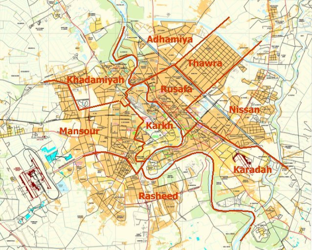
Adhamiyah: Sunni majority, Shiite presence.
Al-Kadhimya: Shiite majority.
Karrada: Shiite majority, Christian presence.
Al-Jadriya Area : Mixed area.
Al-Mansour: Mixed area.
Zayouna: Mixed neighborhood.
Dora: Mixed area, mostly Sunni. Former Christian presence (most have fled)
Sadr City: Almost exclusively Shiite.
Hurriya City: Shiite majority, Sunni presence.
Baghdad Al-Jadida(New Baghdad): Shiite majority, Christian presence.
Al-Sa'adoon area : Mixed area.
Bab Al-Moatham : Sunni majority, shiite presence.
Bab Al-Sharqi : Mixed area.
Al-Baya' : Shiite majority, Sunni presence.
Al-Saydiya : Sunni majority, Shiite presence.
Al-A'amiriya : Sunni majority, Shiite presence.
Al-Shu'ala: Almost exclusively Shiite.
Al-Ghazaliya: Sunni majority, Shiite presence.
Al-Za'franiya: Shiite majority, Sunni presence.
Hayy Ur: Almost exclusively Shiite.
Sha'ab City: Shiite majority, Sunni presence.
Hayy Al-Jami'a: Sunni majority, Shiite presence.
Al-Adel: Sunni majority, Shiite presence.
Al:Khadhraa: Sunni majority, Shiite presence.
Hayy Al-Jihad: Mixed area.
Hayy Al-A'amel: Shiite majority, Sunni presence.
Haifa Street
Al-Rashid Street -- the city's main street, stretching from North Gate to South Gate.
Hilla Road -- Runs from the South into Baghdad via Yarmouk (Baghdad)
Caliphs Street -- site of historical mosques and churches.
Sadoun Street -- stretching from Liberation Square to Masbah
Mohammed Al-Qassim highway near Adhamiyah
Abu Nuwas Street -- runs along the Tigris from the from Jumhouriya Bridge to the 14th July Suspended Bridge
Damascus Street -- goes from Damascus Square to the International Airport Road
Mutanabbi Street -- A street with numerous book-shops, named after the 10th century Iraqi poet Al-Mutanabbi
Rabia Street
Arbataash Tamuz (14th July) Street (Mosul Road)
Muthana al-Shaibani Street
Bor Said (Port Said) Street
Thawra Street
Falastin (Palestine) Street
'Ordon (Jordan) Street
Matar Baghdad Al-Dawli (Airport Road) ((Formerly known as Matar Saddam Al-Dawli))
Reconstruction of Iraq
List of places in Iraq
Firdus Square
Baghdad City Hall
Baghdad Arabic
Baghdad Airport Road
Baghdad bridge stampede
Baghdad Security Plan
"Baghdad." Encyclopædia Britannica. 2006. Encyclopædia Britannica Online. 13 November, 2006.
"Mortality after the 2003 invasion of Iraq: a cross-sectional cluster sample survey"PDF (242 KiB). By Gilbert Burnham, Riyadh Lafta, Shannon Doocy, and Les Roberts. The Lancet, October 11, 2006
Baghdad from GlobalSecurity.org
Hattstein, Markus; Peter Delius (2000). Islam Art and Architecture, 96. ISBN 3-8290-2558-0.
Encyclopedia Iranica, Columbia University, p.413.
By Desert Ways to Baghdad, by Louisa Jebb (Mrs. Roland Wilkins), 1908 (1909 ed) (a searchable facsimile at the University of Georgia Libraries; DjVu & layered PDFPDF (11.3 MiB) format)
A Dweller in Mesopotamia, being the adventures of an official artist in the garden of Eden, by Donald Maxwell, 1921 (a searchable facsimile at the University of Georgia Libraries; DjVu & layered PDFPDF (7.53 MiB) format)
Map of Baghdad
Interactive map
Iraq - Urban Society
Envisioning Reconstruction In Iraq
Description of the original layout of Baghdad
Ethnic and sectarian map of Baghdad - Healingiraq
Baghdad Renaissance Plan
UAE Investors Keen On Taking Part In Baghdad Renaissance Project
Man With A Plan: Hisham Ashkouri
Renaissance Plan In The News
ARCADD, Inc.
Kabul, City of Light Development
Kabul - City of Light, 9 Billion dollar modern urban development project
Sindbad Hotel Complex and Conference Center
Song - Birds Over Baghdad
Baghdad Treasure
Baghdad Burning Riverbend
Electronic Iraq
Maps and aerial photos for Coordinates:
- Mapping from Multimap or GlobalGuide or Google Maps
Aerial image from TerraServer
Satellite image from WikiMapia
Mapping from OpenStreetMap

No comments:
Post a Comment